Archived Project
Website: http://www.mappingararat.com/
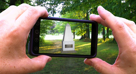
Description: Mapping Ararat is an augmented reality project that navigates through an imaginary Jewish homeland. It offers the user/participant the tools to imagine an alternative historical outcome for Major Mordecai Noah’s plan to turn Grand Island, New York into Ararat, a city of refuge for the Jews during the 1820’s. Utilizing cutting-edge digital media technologies such as augmented reality and simulated cartography, this project gives Ararat a virtual chance to become the Jewish homeland that its founder had envisioned nearly two centuries ago. The project consists of an on-site augmented reality walking tour that haunts the contemporary landscape of Grand Island as well as an interactive cartographic landscape set up in a 3D virtual world within a gallery installation. In addition, Mapping Ararat generates the vernacular artifacts common to all modern nation-states whether money, postcards or newspapers.
Contributors:
- Louis Kaplan, Professor department of Art History, University of Toronto, Mississauga
- Melissa Shiff, Research Associate, Sensorium: Centre for Digital Arts and Technology at York University
- John Craig Freeman, Public Artist and Associate Professor, New Media, Emerson College
- Sarah James, Graphic Design
- Reena Katz, Soundscape
- Elizabeth Hirst, 3D Modelling
- Ultan Byrne, 3D Modelling
- Niki Sehmbi, Photoshop
- Stev’nn Hall, After Effects
Funders: SSHRC

